Design Guidelines
The Waterfront Commission requires that all developments within the Waterfront District undergo design review by the Commission and its Design Review Committee subject to the design and performance standards below. The guidelines shall apply to all new construction, expansions and/or additions of 50% of the gross floor area of existing buildings, or changes to exterior building facades for multifamily and nonresidential development, and to proposed demolution of existing buildings.

Metacomet District Design Guidelines
The Metacomet district is presently the land occupied by the defunct Metacomet Golf Club. The District is bounded by Veteran’s Memorial Parkway, Lyon Avenue, Fort Street, and Watchemoket Cove.
The site is characterized by rolling greens and naturalized landscape design. The property is adjacent to the Veterans Memorial Parkway, Watchemoket Cove, and the East Bay Bike Path. This area is characterized by extensive naturalized green landscapes, low one- and two-story structures (mostly one- and two-family residential buildings) with open yards and substantial mature tree canopy. The area surrounding this site enjoys views to the cove, the Providence River, and the Providence city skyline in the distance.

Bold Point Design Guidelines
The Bold Point sub-district generally extends from the Washington Bridge (I-195) and extends from the waterfront inland easterly to include portions of Warren Avenue (the historic area of the former Watchemoket Square), and First Street (from Warren Avenue to Mauran Avenue). The existing roadway network includes Warren Avenue, First Street, Mauran Avenue, Boston Street, Veteran’s Memorial Parkway, Water Street, Pier Road, and Tangent Street (a paper street).

Kettle Point Design Guidelines
The Kettle Point sub-district extends from the Watchemoket Cove southerly to the Squantum Woods Reservation, an open space park owned by the City of East Providence. The Squantum Woods Reservation also borders this district to the east. The district extends down to the Providence River at is western boundary.
Access to this district is from a road off the Veteran’s Memorial Parkway, approximately opposite Interlocken Road. This district is traversed by the East Bay Bicycle Path. The properties included within this district were previously utilized for petroleum and related products storage and distribution.

Crook Point Design Guidelines
The Crook Point sub-district generally extends along the Seekonk River from the Washington Bridge (Interstate 195) northerly to the Henderson Bridge. This redevelopment area is bounded on the west by the Seekonk River, on the south by Interstate 195 (Washington Bridge), on the east by Valley Street, North Brow Street, and a small portion of South Brow Street, and on the north by the Henderson Bridge. The prominent geographic feature of the land in this redevelopment area is Crook Point, which is owned by the State of Rhode Island.

Pawtucket Avenue Design Guidelines
The Pawtucket Avenue sub-district is included primarily to address the former Fram property and adjacent vacant property. The Pawtucket Avenue sub-district is located at 10 New Road and Pawtucket Avenue, and 105 Pawtucket Avenue, the property is the former Fram Automotive property. A limited number of properties are also located in the Taunton Avenue Special Development Sub-District. Portions of Warren Avenue and properties on Taunton Avenue and Lyon Avenue are included in the northern Waterfront District because certain properties are recognized as gateway locations to the waterfront, or for the purposes of strengthening existing commercial areas and discontinuing nonperforming blighting influences. This area is characterized by large open spaces with buildings set into green, naturalistic park settings.

Taunton Avenue Design Guidelines
The Taunton Avenue sub-district consists of properties which are impacted by the proposed transportation improvements for the Interstate 195 highway ramping changes, and three vacant and deteriorating properties along Taunton Avenue. The City of East Providence is also conducting ongoing planning and implementation efforts relating to commercial corridor revitalization for Taunton Avenue and Warren Avenue.

Phillipsale Design Guidelines
The Phillipsdale sub-district extends from Roger Williams Avenue northerly to the Narragansett Bay Commission Bucklin Point Water Pollution Control facility. This sub-district includes properties located off Bourne Avenue (west of Roger Williams Avenue) and Noyes Avenue. The westerly boundary of this sub-district extends to the Seekonk River. The former Ocean State Steel property is located within this sub-district. The Roger Williams Avenue corridor (including properties on both sides of the street) from Magnolia Avenue northerly to approximately Ruth Avenue is included within this sub-district.
Veterans Memorial Parkway Design Guidelines
The Veterans Memorial Parkway sub-district generally extends from Teofila Braga Way to Watchemoket Cove. Properties on the westerly side of the Veteran’s Memorial Parkway are included in this Special Development Sub-district from the beginning of the Parkway to, and including, the Chevron/Gulf Oil property.

Dexter Road Design Guidelines
The Dexter Road sub-district generally extends from the Henderson Bridge northerly to Omega Pond. This sub-district includes all those properties fronting on, or gaining access from, Dexter Road. This District is bordered on the east in part by Massasoit Avenue and by a Providence and Worcester rail corridor. The western boundary of the subdistrict extends to the Seekonk River.
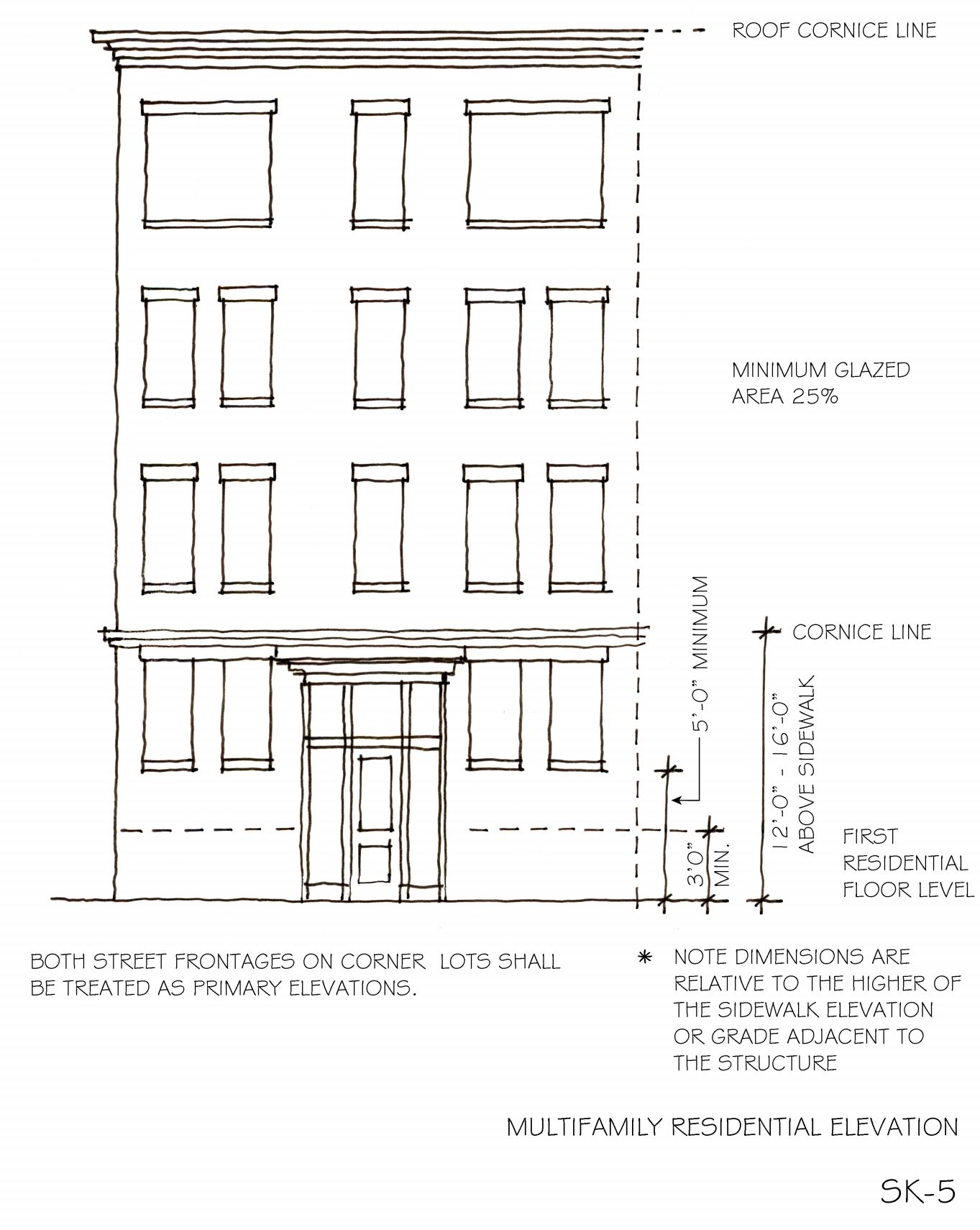
Example Sketches:
Below are the sketches referred to in the Design Guidelines. Note: These are only sample sketches.
Mixed Use and Commercial Elevation

Multi-Family Residential Elevation
Townhome Residential Elevation

Single Family Residential Elevation
